As meteorological winter ends mildly, Philadelphia will see wild start to spring
Finally, we close the books on winter 2024-2025. Saturday is the meteorological start of spring. While Philadelphia will see a mild end to winter, the area can expect a wild start to spring.
The average temperature this winter season has been the coldest in a decade. Unbelievably, with all that cold air, we have had less than half our normal snowfall.
As of March 1, we should have had 18.8 inches of snow, but only 8.1 inches have fallen, which is 10.7 inches below average. Yes, we could still see some monster snowfall in March, but right now, the pattern favors rain over snow through the first week.
Ironically, we are ending this final month of winter above average with highs in the 50s. However, that's about to change, and now you'll need to prepare for a weather whiplash as we go from mild to wild.
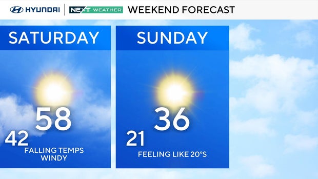
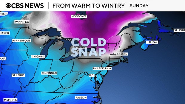
March is coming in more like a lion than a lamb this weekend. Another push of polar air will lead to a 25-degree drop from highs near 60 early Saturday afternoon to the mid-30s Sunday afternoon.
On Sunday, plan on layering up with all the winter gear. It will be dry but blustery with winds gusting to 30 mph, creating wind chills in the teens and 20s.
Looking past the weekend, what about the first full week of March?
Think rebound, with highs climbing from near 40 on Monday to the mid-60s on Wednesday. That climb comes with a catch.

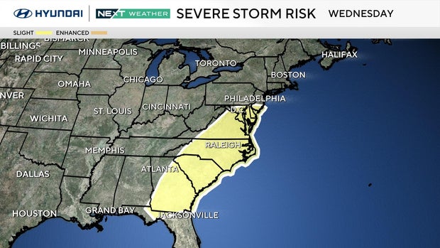
A vigorous spring storm system will cross the area next week. As a warm front lifts north of Philadelphia, gusty south winds will push our temperatures to the 60s on Wednesday.
This big warm-up will be followed by a strong cold front that could trigger strong thunderstorms on Wednesday afternoon and evening.
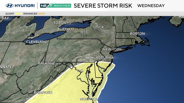
NOAA's Storm Prediction Center has already placed us in a highlighted area of possible severe weather Wednesday.
It is too early to determine the intensity level of the storms or whether they will even reach severe limits, but check back here frequently. The Next Weather Team will keep you updated around the clock about next week's storms.
Colder air arrives behind the front to end the week. Skies will clear Thursday and Friday, and temperatures will return to more seasonable levels in the upper 40s to low 50s.
Next weekend, there is another chance for showers and storms.
This roller coaster of weather is really no surprise since the three spring months (March, April and May) are the transition months from winter cold to summer heat.
In March, everything is possible: cold, heat, snow, rain and thunderstorms, which mark the start of our convective season.
The potential for our first spring storms next week is a reminder to dust off the severe weather plan for you and your family. Make sure you all know what to do and where to go at home, school and work.
On Sunday morning, we will also usher in the start of daylight saving time, so remember to flip your clocks ahead one hour when you go to bed Saturday night.


