Rain and snow return to Northern California weather forecast as March kicks off
After a quiet end to February, March has brought a change of pace with rain and snow in the first few days -- and more in the forecast through the next two weeks.
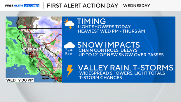
Monday brought a brief break in the storm activity as another storm system aims for Northern California on Wednesday.
Similar to the weekend, it will be another fast-moving storm system bringing widespread Valley showers and moderate Sierra snow from Tuesday night through Wednesday night, with lingering showers possible in the Sierra through Thursday.
When will Northern California see more rain?
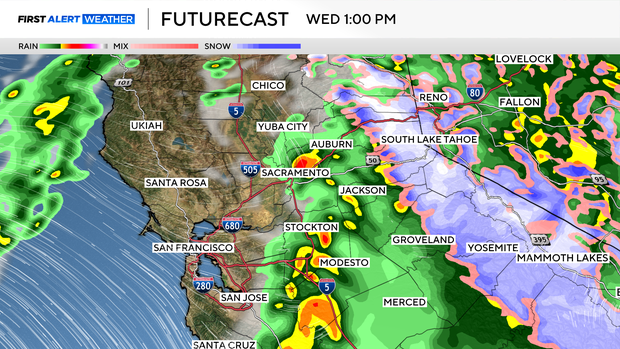
A few sprinkles are possible in the valley on Tuesday afternoon as clouds fill in. Rain begins to pick up late Tuesday night into early Wednesday as the storm moves into the Central Coast.
Showers begin to spread from the southwest to the northeast through Wednesday morning. Our best chances for heavier precipitation will be across the San Joaquin Valley for areas south of Highway 50.
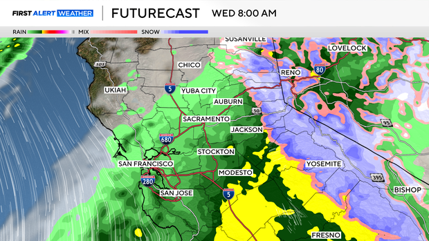
Rain will be lighter across the northern end of the Sacramento Valley but increase for areas along and south of Interstate 80.
Wednesday won't be a washout, but keep the umbrella handy as showers pass through.
The foothills will be busy through the day as showers begin to fill in through the morning. Heavier pockets of rain will be possible, especially for areas south of Highway 50 from El Dorado to Tuolumne counties.
Impacts from the rain will be minor but expect wet roads during commute hours.
When will it start snowing in the Sierra Nevada?
Snow will begin to fill in through the morning, with the heaviest snow staying above 5,000 feet through the afternoon.
A Winter Weather Advisory has been issued starting at 4 a.m. on Wednesday through 4 p.m. Thursday for moderate to heavy snowfall above 5,000 feet.
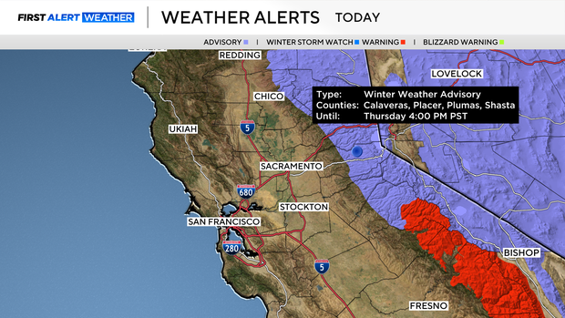
Expect chain controls, slick roads, and delays for any mountain travel early Wednesday into early Thursday.
Wind will be calmer with this storm, but expect periods of low visibility as snow rates pick up at times through Wednesday evening.
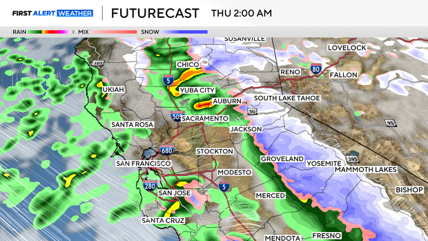
Snow will begin to clear by Thursday night as the storm moves east.
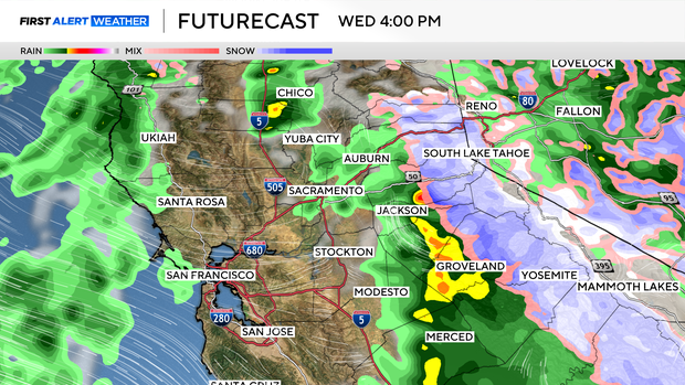
Chance of isolated thunderstorms
With breaks in the rain and peaks of sun during Wednesday afternoon and evening, a few thunderstorms will be possible.
Any storms that develop will bring brief heavy rain, small hail, gusty winds, and possible funnel clouds.
The best chances of storm development will be for areas along and south of I-80, across portions of the Sacramento and San Joaquin valleys, especially as you near the foothills.
How much rain and snow is Northern California expecting?
Again this storm won't bring a washout to the valley, but areas in the San Joaquin Valley should be prepared for brief heavy rain at times.
This storm is taking a more southern route, focusing on the Central Valley, and with it will bring higher totals by Thursday.
Areas like Stockton and Modesto can expect 0.25-1'' of rain by Thursday, depending on where thunderstorms develop.
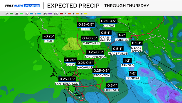
Across the Sacramento Valley, Chico and Marysville will fall in the lower end of rain amounts with 0.10-0.25'' expected. Sacramento can expect up to 0.50'' of rain.
Foothill spots south of Highway 50 will see higher amounts than areas further north. But many areas can expect up to 1'' of rain by Thursday. With amounts fluctuating depending on thunderstorms.
Across the Sierra, the highest amounts will be above 6,000 feet in elevation. Expect 6-12'' of snow across Sierra passes.
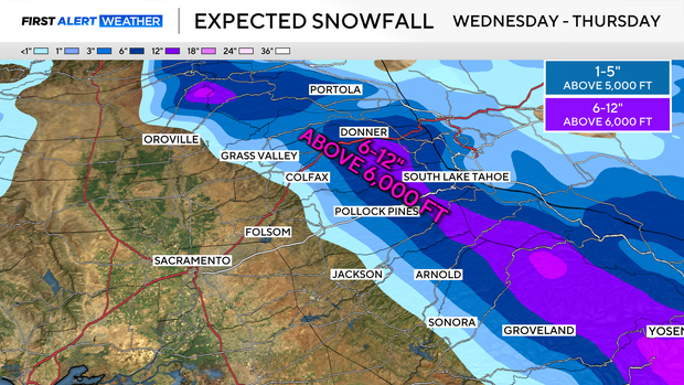
3-5'' of snow for elevations above 5,000 feet, with a light dusting possible down to 3,500 feet possible.
Make sure to check road conditions and be prepared for winter travel on Wednesday and Thursday.
Looking ahead
March is panning out to be a busy month for Northern California with more storms on the horizon through the 17th.
Our next storm moves in Sunday night into early next week with another shot of valley rain and Sierra snow.
The track and timing of this storm still remains a question, so make sure to stay with the CBS Sacramento First Alert Weather team for updates through the end of the week.
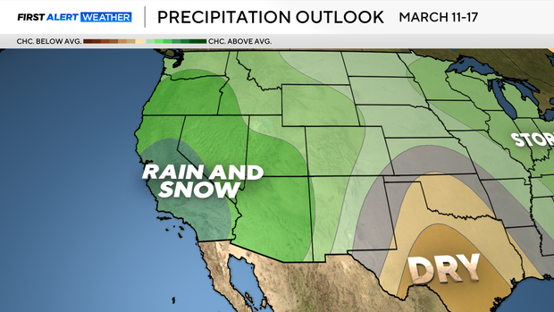
Long-range models show the storm door remains open across the West Coast through March 17, with another good rain and snow-maker moving in next Wednesday and Thursday. Check back for updates!